By: Romano House of Stamp sales ltd
lot # 92 - judaica judaica historical literature
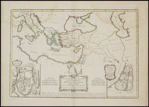
1783 map by Rigobert Bonne, Carte des Regions et des Lieux dont il est parlé dans le Nouveau Testament, A beautiful example of Rigobert Bonne's 1783 decorative map of the lands of the Bible's New Testament. Bonne's map covers from Italy eastward to include the eastern Mediterranean, parts of Africa, egypt, Persia, Arabia and Asia Minor. It includes both the Black Sea (Pont-euxin) and the Caspian Sea (Mer Caspienne). Numerous Biblical sites noted throughout. An inset in the lower left quadrant details the city of Jerusalem in the times of Jesus Christ. The Temple, the Fort of Sion, the Palace of Solomon, the Mount of Olives, and many other well-known Biblical sites are identified. A second inset in the lower right quadrant focuses on Judea under King Herod. A decorative baroque title cartouche appears at the bottom center. Drawn by R. Bonne in 1783 for issue as plate no. 36 in Jean Lattre's 1783 final issue of the Atlas Moderne. Source: Lattre, Jean, Atlas Moderne ou Collection de Cartes sur Toutes les Parties du Globe Terrestre, c. 1783. Ref. Phillips (Atlases) 664. British Libarary (World), col. 384-385. Map image is 45x30cm, mounted on art stock which is 62x77cm. Some staining, mainly at top. Estimate $200-$400
About The Seller
Romano Sale House of Stamps Ltd.
The Romano Sale House was established in early 1998. After years in the stamp business, as Images/Auctioneers and sole suppliers of LINDNER philatelic accessories in Israel, Romano Sale House has... Read More
Send Email to Romano House of Stamp sales ltd Or Visit WebSite
more from this sale


